Nepal's 'Himalayan tsunami': what we know / Photo: © AFP

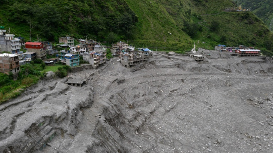
Nepal is reeling from a deadly Himalayan glacial mountain collapse on the border with China that has killed more than 1,300 people and left upwards of 5,600 missing in both countries.
Scientists have been examining the August 26 catastrophe, dubbed a "Himalayan tsunami" by Nepal's foreign minister.
Here is what experts -- including from the Kathmandu-based International Centre for Integrated Mountain Development (ICIMOD) and the HiRISK group, focusing on Asia's mountains -- have deciphered so far.
- What happened? -
On August 26 at 8:37 am (0252 GMT), a mass of ice and rock broke away from the north face of Nepal's Langtang Lirung mountain, sending a huge mass of debris racing down the valley.
The collapse began at an altitude of about 5,200 metres (17,060 feet) with a section more than a kilometre (0.6 miles) wide and extending roughly 700 metres vertically, according to ICIMOD.
That mass of rock and ice plunged about 800 metres onto a debris-covered glacier, before surging downhill, briefly damming the Lhende River. Water and debris then burst downstream.
The debris travelled about 20 kilometres, dropping 1,700 metres at Rasuwagadhi in only seven minutes, ICIMOD geologist Sudan Bikash Maharjan told AFP.
"The elevation difference is high, within a very short length," Maharjan said. "So it just rushed down like a bullet train."
The collapse swept up vast quantities of loose material as it descended, helping create an exceptionally destructive and fast-moving flow.
Experts are still investigating the large volume of water that allowed the debris to travel far downstream.
It also created two lakes. One has slowly drained. Experts believe the second one will not cause a high-magnitude flood.
- Why did the mountain collapse? -
Experts say several factors may have contributed, but it is too early to identify a single trigger.
The glacier in the area retreated by about 450 metres between 1990 and 2020, exposing rock that had previously been covered by ice.
Changes in temperature, moisture and permafrost may have weakened fractures in the exposed rock, while water entering cracks could have helped destabilise the slope.
But there was no earthquake, exceptional rainfall or sudden period of extreme heat immediately before the collapse, experts said.
"To pinpoint 'this is the cause', we need to go to the field, do the analysis," Maharjan said.
A major earthquake in 2015 may also have contributed to longer-term instability. But experts are examining whether cracks may have developed in the mountain over a longer period.
- Was role does climate change play? -
Climate change may have contributed to conditions that made the slope more vulnerable, but experts caution against attributing the disaster solely to rising temperatures.
Warming has accelerated glacier retreat across the Himalayas, exposing previously ice-covered rock to changing temperatures and water conditions.
Permafrost degradation may also weaken mountain slopes and allow water to penetrate deeper into fractures.
"Climate change makes all this more likely," geoscientist Jakob Steiner said, while noting that mountain collapses are also part of natural geological processes.
- Could it have been predicted? -
Scientists are examining possible warning signs, including evidence that the glacier accelerated in the weeks before the collapse, and a sudden increase in meltwater shortly beforehand.
But neither was enough to predict with certainty that a catastrophic collapse was imminent.
Steiner said the analysis should not suggest that authorities in Nepal or China would have known the mountain was about to fail.
"There are so many mountains in the region," he said.
- What may help prevent similar disasters? -
Experts hope that understanding the events of August 26 will lead to the development of tools capable of predicting a recurrence.
"We are using... this knowledge now to be better prepared in future -- to find tools that let us focus in on that 'one needle in the haystack', that we actually need to pay attention to," Steiner told AFP.
Experts say better long-term monitoring, data sharing and coordination are crucial.
"We really need a dedicated mechanism... which works around the clock," disaster specialist Saswata Sanyal told AFP.
N.Patterson--TFWP