Tectonic Metals Intersects 5.61 g/t Au Over 41.15 m, Including 12.94 g/t Au Over 13.72 m, Within 2.86 g/t Au Over 91.44 m, Strengthening Evidence for a Second Gold System at the Flat Gold Project

High-Grade Mineralization Extends to Bottom of Hole, Located 100 m South of the 2025 Black Creek Discovery
VANCOUVER, BC / ACCESS Newswire / November 2, 2026 / Tectonic Metals Inc. ("Tectonic"or the "Company") (TSXV:TECT)(OTCQX:TETOF) today announced assay results from six reverse circulation ("RC") drill holes at Black Creek, highlighted by CMR26-159, which returned 2.86 grams per tonne gold ("g/t Au") over 91.44 metres ("m"), including 5.61 g/t Au over 41.15 m and 12.94 g/t Au over 13.72 m. Located 100 m south of Black Creek's 2025 discovery hole, CMR26-159 delivered the longest mineralized intercept to date and ended in high-grade mineralization, leaving the system open at depth.
Black Creek is one of six district-scale Reduced Intrusion-Related Gold System ("RIRGS") targets at Tectonic's flagship 99,840-acre Flat Gold Project ("Flat") in southwest Alaska, U.S. Located six kilometres ("km") north of Chicken Mountain, where a maiden Mineral Resource Estimate ("MRE") is targeted for Q1 2027, Black Creek has delivered repeated high-grade gold intercepts within broad mineralized envelopes, demonstrating continuity of mineralization across a growing footprint and providing further evidence that Tectonic is vectoring towards a second gold system within the Flat district.
Black Creek Drill Assay Highlights:
Tony Reda, Co-Founder, President and CEO, commented:
"We could not have asked for a better start at a brand-new exploration target. In just 18 holes and 1,600 m of drilling, we have intersected gold mineralization in 17 holes, including four that have delivered significant high-grade intervals: 4.50 g/t Au over 48.77 m, 5.09 g/t Au over 21.34 m, 2.75 g/t Au over 38.10 m and, now, 5.61 g/t Au over 41.15 m. Notably, all three recent holes ended in mineralization, which raises a compelling question: how far does this higher-grade gold extend at depth?
"What makes Black Creek even more exciting is that we have tested only a fraction of the target. Drilling from both of our initial campaigns has outlined mineralization across an area of approximately 100 by 200 m and to a vertical depth of less than 200 m, within a much larger 1,500 by 700 m gold-in-soil anomaly, of which over 85% remains untested. Both sit within an even larger 1.5 by 2.5 km geophysical anomaly interpreted to represent an intrusive centre.
"As Chicken Mountain advances towards its maiden Mineral Resource Estimate and Preliminary Economic Assessment in 2027, Black Creek is emerging as another potentially significant gold centre at Flat. With high-grade gold intercepts, broad mineralized intervals and substantial ground yet to be explored, we see a compelling opportunity to further define the scale and continuity of mineralization and evaluate its potential to support a second mineral resource within the district."
High-Grade Gold Continues to Expand at Black Creek
Tectonic's first drilling at Black Creek in 2025 discovered high-grade gold in hornfelsed sedimentary rocks near the eastern margin of the Black Creek intrusion (see news release dated January 29, 2026). Follow-up drilling in 2026 extended the mineralized footprint, with CMR26-152 and CMR26-153 ending in mineralization (see news release dated August 25, 2026). CMR26-159 now extends high-grade gold a further 30 m south (see Figures 1, 3 and 4).
Black Creek Key Intercepts to Date
Hole | Reported | Interval | Including | Ended in Min. |
|---|---|---|---|---|
CMR25-059 | Jan 29, 2026 | 3.80 g/t Au over 57.91 m from surface | 4.50 g/t Au over 48.77 m; 7.79 g/t Au over 24.38 m; 15.19 g/t Au over 6.10 m | No |
CMR26-152 | Aug 25, 2026 | 5.09 g/t Au over 21.34 m | 17.34 g/t Au over 6.10 m | Yes |
CMR26-153 | Aug 25, 2026 | 1.89 g/t Au over 57.91 m | 2.75 g/t Au over 38.10 m | Yes |
CMR26-159 | This release | 2.86 g/t Au over 91.44 m | 5.61 g/t Au over 41.15 m; 12.94 g/t Au over 13.72 m | Yes |
Note: Downhole lengths reported; true widths not yet determined. Included intervals are nested and not additive.
The six new holes reported today provide important geological context for refining the Black Creek target. Gold mineralization is interpreted to be structurally controlled, with higher-grade zones potentially exhibiting steep dips and plunges. Additional drilling and oriented core analysis will help constrain the geometry, continuity and structural controls of these zones. In addition to CMR26-159 reported above, highlights from the five remaining holes include:
Geological Setting: A New Model for the Flat District
Host rock and mineralization style: Gold at Black Creek is hosted within altered and hornfelsed Kuskokwim Group sedimentary rocks, associated with quartz to quartz-carbonate-stibnite veining, oxidation, fracturing and intermediate to mafic dykes. This is a fundamentally different setting from the monzonite-dominant mineralization drilled at Chicken Mountain, demonstrating that gold at Flat is not confined to a single intrusion or host rock.
Structural controls: Gold occurs in both sedimentary rocks and dykes, suggesting that structure, rather than rock type, is the primary control on mineralization. Results from the 2025 and 2026 programs indicate that structures acted as fluid conduits, generating broad mineralized envelopes around higher-grade gold shoots.
A targeting vector: A modelled mafic dyke plunge associated with higher-grade gold mineralization provides a testable direction for step-out drilling (see Figure 5 long section).
District-scale implications: Hornfelsed sedimentary rocks occur along intrusion margins throughout the Flat district, including at Chicken Mountain, Golden Apex, Horseshoe, Jam and Caribou. Black Creek establishes a district-relevant exploration model in a host rock that expands the prospective area beyond intrusion-hosted mineralization alone. The emergence of significant gold mineralization at both Chicken Mountain and Black Creek supports the potential for multiple resource centres associated with the 20-km-long Flat volcano-plutonic complex.
Exploration Potential and Next Steps at Black Creek
The broader area at Black Creek has a long history of gold production. Placer mining on Black Creek and Upper Otter Creek produced approximately 450,000 ounces of gold, and a historical hard-rock mine at Black Creek reportedly produced approximately 2,707 ounces at an average grade of 12.00 g/t Au between 1925 and 1938.[2] This history points to a fertile gold system, although it does not establish the size or continuity of the mineralization intersected in current drilling.
To date, Black Creek remains largely untested. Drilling has covered only the eastern portion of a 1,500 m by 700 m gold-in-soil anomaly (see Figure 2), leaving over 85% of the anomaly untested. The gold-in-soil anomaly sits within a 1.5 by 2.5 km geophysical target, where drilling has confirmed the presence of intrusive rocks.
Follow-up exploration is prioritized to test the potential at Black Creek:
Tectonic's Near-Term Catalysts
Year-to-date through October 2026, Tectonic completed 31,000 m of drilling in 166 holes, focused mainly on resource delineation and expansion at Chicken Mountain. This release reports results from 525 m in six RC holes at Black Creek. Upcoming Company catalysts include:
Maps and Multimedia
Figure 1: Regional geology map of the Flat Gold Project and map of the Black Creek intrusion drilling area. Holes in green are new assays from 2026 up to and including this news release.
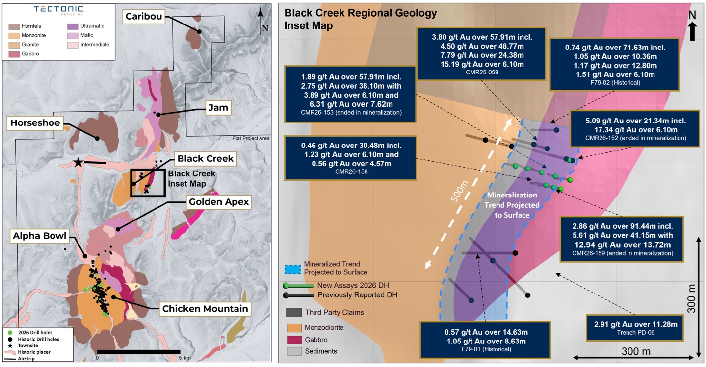
Figure 2: Plan view of anomalous gold-in-soil map measuring 1,500 m by 700 m within the Black Creek target area.
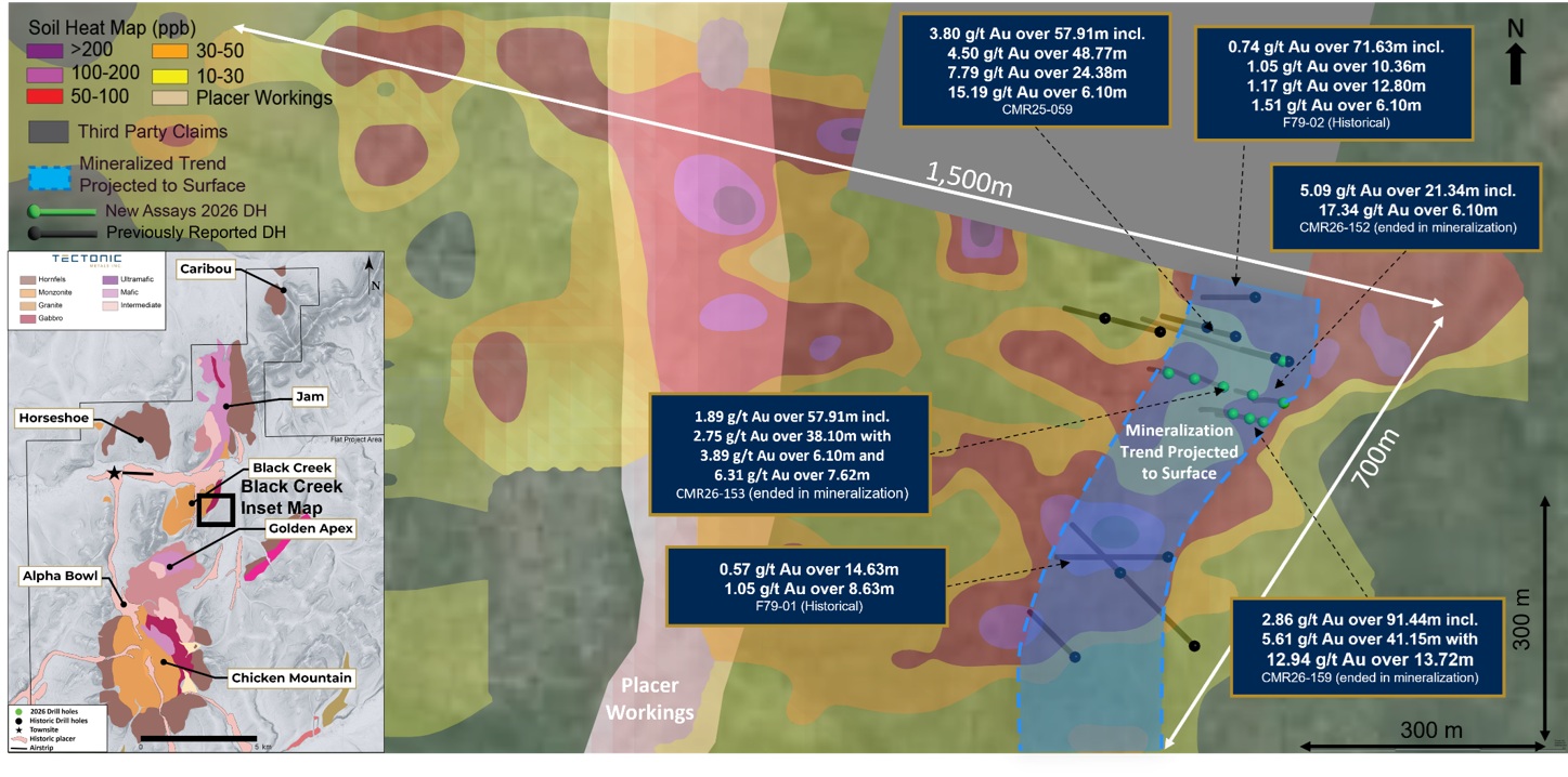
Figure 3: Plan view of updated geological model of Black Creek target Area, notably updated hornfels and mafic dykes that are associated with higher-grade mineralization.
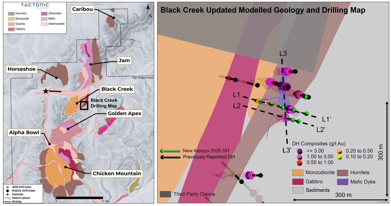
Figure 4: Cross section L2-L2', looking north showing CMR26-159.
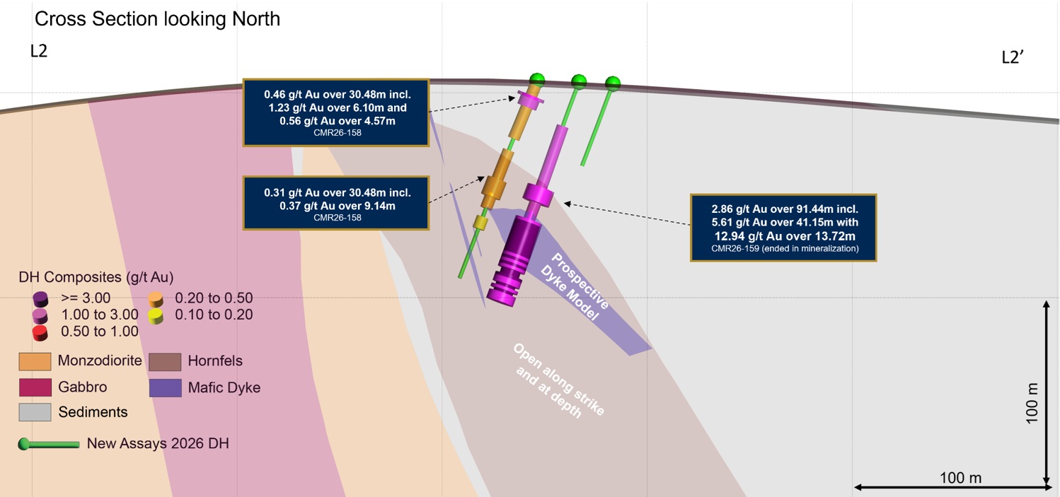
Figure 5: Longitudinal section L3-L3′, looking east, highlighting the modelled mafic dyke plunge that has been observed with higher-grade mineralization.
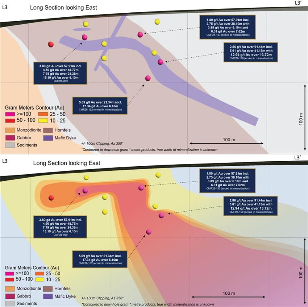
Table 1: Black Creek Assay Highlights
| Hole ID | From (m) | To (m) | Length (m) | Au (g/t) | |
| CMR26-154 | 1.52 | 4.57 | 3.05 | 0.20 | |
15.24 | 28.96 | 13.72 | 0.13 | ||
70.10 | 74.68 | 4.57 | 0.55 | ||
| CMR26-155 | 39.62 | 41.15 | 1.52 | 0.14 | |
50.29 | 51.82 | 1.52 | 1.99 | ||
68.58 | 71.63 | 3.05 | 0.28 | ||
77.72 | 79.25 | 1.52 | 0.10 | ||
88.39 | 94.49 | 6.10 | 0.16 | ||
100.58 | 102.11 | 1.52 | 0.11 | ||
| CMR26-156 | 0.00 | 1.52 | 1.52 | 0.12 | |
19.81 | 42.67 | 22.86 | 0.22 | ||
Including | 19.81 | 25.91 | 6.10 | 0.40 | |
56.39 | 59.44 | 3.05 | 0.50 | ||
| CMR26-157 | No Significant Intersections | ||||
| CMR26-158 | 0.00 | 30.48 | 30.48 | 0.46 | |
Including | 7.62 | 13.72 | 6.10 | 1.23 | |
and | 19.81 | 24.38 | 4.57 | 0.56 | |
36.58 | 67.06 | 30.48 | 0.31 | ||
Including | 51.82 | 60.96 | 9.14 | 0.37 | |
71.63 | 77.72 | 6.10 | 0.13 | ||
| CMR26-159 | 22.86 | 114.30 | 91.44 | 2.86 | |
Including | 73.15 | 114.30 | 41.15 | 5.61 | |
with | 74.68 | 88.39 | 13.72 | 12.94 | |
Note: All reported intercepts are reported as downhole lengths, as insufficient data exists to determine true widths. Select composites utilizing 0.10, 0.30 or 0.50 g/t Au cut-offs, with a maximum 3.2 m continuous (two sample) below the cut-off inclusion.
Table 2: Black Creek RC Hole Collar Locations and Orientations
Hole ID | Type | Azimuth | Dip | Length | UTM E | UTM N | Purpose |
|---|---|---|---|---|---|---|---|
CMR26-154 | RC | 285 | -70 | 94.49 | 555415 | 6923671 | Exploration |
CMR26-155 | RC | 285 | -70 | 103.63 | 555381 | 6923680 | Exploration |
CMR26-156 | RC | 285 | -70 | 67.06 | 555350 | 6923686 | Exploration |
CMR26-157 | RC | 285 | -70 | 42.67 | 555462 | 6923629 | Exploration |
CMR26-158 | RC | 285 | -70 | 103.63 | 555426 | 6923639 | Exploration |
CMR26-159 | RC | 285 | -70 | 114.30 | 555446 | 6923633 | Exploration |
Qualified Person
Tectonic Metals' disclosure of technical or scientific information in this press release has been reviewed, verified and approved by Peter Kleespies, M.Sc., P.Geo., Chief Geological Officer, who is a Qualified Person in accordance with Canadian regulatory requirements set out in National Instrument 43-101.
Analytical work for the 2026 Flat project drilling program was performed by ALS Global ("ALS"), an internationally recognized and accredited laboratory independent of Tectonic. On-site, core and reverse circulation samples were sealed in security-tagged bags and shipped under strict chain-of-custody protocols to the Lynden Transport logistics operator in Anchorage, Alaska, for delivery to ALS facilities in Vancouver, British Columbia.
Upon arrival at the laboratory, samples were dried, crushed to 2 mm and riffle split into nominal 500-gram subsample aliquots (prep codes CRU-31, SPL-32a). One portion was analyzed for gold using PhotonAssay™ (ALS code Au-PA01). PhotonAssay™ uses high-energy X-rays to determine gold content from a large sample aliquot, typically 500 g of crushed material. The method is non-destructive and is particularly suited to gold systems where larger sample aliquots may improve representativity. If additional nominal 500-gram PhotonAssay TM analysis splits are conducted for a given sample, results from all splits are combined on a weight average basis. A second portion was pulverized such that 85% of the sample passed 75 µm (PUL-31) and was analyzed by four-acid digestion with ICP-MS finish for 48 elements (ME-MS61), along with aqua regia digestion with ICP-MS finish for trace levels of mercury (Hg-MS42).
Quality assurance and quality control (QA/QC) protocols included the insertion of certified reference material every 20 samples, blank samples at a rate of one in every 25 samples and field duplicate samples (split from the original 1.5 m for RC or core sample intervals) every 25 samples. All QA/QC results returned values within acceptable limits.
About Tectonic Metals Inc.
Tectonic Metals Inc. is a mineral exploration company focused on exploring and developing its flagship Flat Gold Project in southwestern Alaska, covering 99,840 acres of predominantly Native-owned land belonging to Doyon, Ltd., a leading Alaska Native Regional Corporation and one of Tectonic's largest shareholders. The current focus is on advancing the Chicken Mountain target, one of six multi-kilometre-scale intrusion zones at the Flat Gold Project, towards the Company's maiden Mineral Resource Estimate in Q1 2027.
Founded by key members of the Kaminak Gold team behind the discovery and advancement of the Coffee Gold Project, which was acquired by Goldcorp for $520 million in 2016, Tectonic brings a proven track record in exploration, project advancement, capital markets and value creation. Collectively, the team has helped identify more than 40 million ounces of gold, advanced 20 projects through to feasibility, permitted 25 projects, completed over $6 billion in mergers and acquisitions and raised more than $6 billion in capital.
Tectonic's mission is to be a shift in the game: working for our shareholders and the communities where we operate, putting people first, playing big and staying true to our word every step of the way.
On behalf of Tectonic Metals Inc.,
Tony Reda, President and Chief Executive Officer
For further information about Tectonic Metals Inc. or this news release, please visit our website at www.tectonicmetals.com or contact:
Keren Yun, Vice President, Investor Relations
1-888-685-8558 or [email protected]
Cautionary Note Regarding Forward-Looking Statements, Historical Information and Visual Observations
This news release contains "forward-looking statements" and "forward-looking information" (collectively, "forward-looking statements") within the meaning of applicable Canadian securities laws. All statements herein that are not statements of historical fact may be deemed to be forward-looking statements. Forward-looking statements are often, but not always, identified by words such as "may," "will," "should," "anticipate," "believe," "expect," "intend," "plan," "estimate," "potential," "target," or similar terminology, or that events or conditions "may" or "will" occur.
Forward-looking statements in this release include, but are not limited to, statements regarding: the potential for mineralization at Tectonic's projects; the nature, scope, and timing of future exploration activities; the interpretation of geological observations; the possible size or scale of mineralized systems; the receipt of regulatory approvals, and the anticipated benefits of current and future exploration programs.
This release may also refer to historical information, including results from past exploration activities and placer production figures. Any such historical information has not been independently verified by Tectonic, may not be reliable, and should not be relied upon as current, NI 43-101 compliant data.
In addition, this release may contain detailed geological notes, and descriptive observations such as alteration styles, mineralogy and visible gold. These observations are preliminary in nature, may not be representative of the entire interval or system, and should not be relied upon as a guarantee of mineralized assay results or as the basis for any investment decision. Investors and readers are cautioned that visual estimates, core photographs, and geological descriptions are not substitutes for laboratory assay results and do not demonstrate the economic viability of any mineral deposit.
Forward-looking statements are not guarantees of future performance. They are based on a number of assumptions made as of the date such statements are provided, including, among others: assumptions regarding future gold and other metal prices; currency exchange and interest rates; favourable operating and political conditions; timely receipt of permits and regulatory approvals; availability of labour, equipment, and services; stability of financial and capital markets; availability of financing on acceptable terms; accuracy of exploration data and geological models; and the ability to successfully advance planned exploration programs. Many of these assumptions are beyond the control of Tectonic and may prove to be incorrect.
Forward-looking statements are subject to known and unknown risks, uncertainties, and other factors that may cause actual results, performance, or achievements to differ materially from those expressed or implied. These risks include, without limitation: risks inherent to mineral exploration and development; volatility of commodity prices; changes in laws, regulations, and policies; delays or inability to obtain required approvals and permits; availability of financing; general economic, political, and market conditions; labour disputes and shortages; equipment and supply risks; environmental and social risks; competition; inaccuracies in exploration results or geological interpretations; and other risks detailed from time to time in the Company's continuous disclosure filings.
Although management believes the expectations expressed in such forward-looking statements are reasonable as of the date made, there can be no assurance they will prove to be correct. Readers are cautioned not to place undue reliance on forward-looking statements, historical information, or preliminary visual geological observations. Actual results and future events may differ materially from those anticipated. All forward-looking statements contained in this news release are expressly qualified by this cautionary statement. Tectonic disclaims any intention or obligation to update or revise forward-looking statements, whether as a result of new information, future events, or otherwise, except as required by applicable securities laws.
Neither the TSX Venture Exchange nor its Regulation Services Provider (as that term is defined in the policies of the TSX Venture Exchange) accepts responsibility for the adequacy or accuracy of this release.
[1]Hole CMR25-059 reported in January 29, 2026 news release . Holes CMR26-152 and CMR26-153 reported in August 25, 2026 news release.
[2]Historical production figures: " Mineral Occurrence and Development Potential Report, Locatable and Salable Minerals, Bering Sea-Western Interior Resource Management Plan, BLM-Alaska ". Historic hard rock mine production: "Bundtzen et al 1992, Geology and Mineral Resources of Iditarod Mining District, Iditarod B4 and Eastern B-5 Quadrangles, Southwestern Alaska, DGGS Professional Report 97". Historical figures have not been independently verified by Tectonic and are not current mineral resources.
SOURCE: Tectonic Metals Inc.
View the original press release on ACCESS Newswire
J.Barnes--TFWP