
Eagle Plains Reports Anomalous Radioactivity from First Drillholes at the Don Lake Uranium Project, Saskatchewan

CRANBROOK, BC / ACCESS Newswire / August 26, 2026 / Eagle Plains Resources Ltd. (TSX-V:EPL)(OTCQB:EGPLF) ("EPL" or "Eagle Plains") and partner Xcite Uranium Inc. (TSX-V:XRI) ("XRI or Xcite"), are pleased to report that the first three drill holes completed at Eagle Plains' Don Lake Project (" Don Lake" " or the " Project ") have intersected multiple zones of anomalous radioactivity.
The Don Lake uranium project is located near Uranium City, Saskatchewan, and hosts near surface uranium mineralization as well as a past producing uranium mine. In December 2023 Eagle Plains granted Xcite the exclusive right to earn up to an 80% interest in the Don Lake, Gulch, Lorado, Beaver River, Black Bay, and Smitty projects (see Dec 14 news release). The six projects comprising the Xcite option agreements cover 54 Saskatchewan Mineral Deposit Index (SMDI) occurrences and five past-producing uranium mines, and are 100% owned by Eagle Plains. The projects are prospective for Beaverlodge style, basement hosted and unconformity hosted uranium mineralization.
The 1500m, 14-hole program is testing for structurally-controlled uranium mineralization defined by both historical work and results from the 2025-2026 field programs. The program will consist of 1500m of diamond drilling, with 14 holes from 6 different pad locations. The 2026 drilling was contracted to Apex Drilling with crews based out of Uranium City.
Select drill core photos are provided in Figure 4 and Figure 5.
Highlights
Multiple intervals of anomalous radioactivity1 were intersected in all three holes including:
DN26001 1.9m averaging 11571 cps
DN26002 1.1m averaging 23923 cps
DN26003 1.2m averaging 10320 cps
Anomalous radioactivity is generally associated with strongly silica-feldspar, hematite and chlorite altered gabbroic gneiss
4 additional targets to be tested at Don Lake
"Intersecting this level of near surface radioactivity in the first three holes of the 2026 drill program demonstrates the prospectivity and underexplored nature of the Don Lake Project specifically and the entire Beaverlodge district in general." said Chuck Downie, President and CEO of Eagle Plains.
The first three holes at Don Lake were completed in the A Zone area. Historical exploration, including fourteen trenches and 20 shallow drill holes, have outlined anomalous uranium mineralization over approximately 213m of strike length.
Table 1 Drill Information
Hole ID | Zone | Azimuth | Dip | Total |
DN26001 | Don Main A Zone | 80 | -45 | 96 |
DN26002 | Don Main A Zone | 50 | -45 | 111 |
DN26003 | Don Main A Zone | 355 | -45 | 105 |
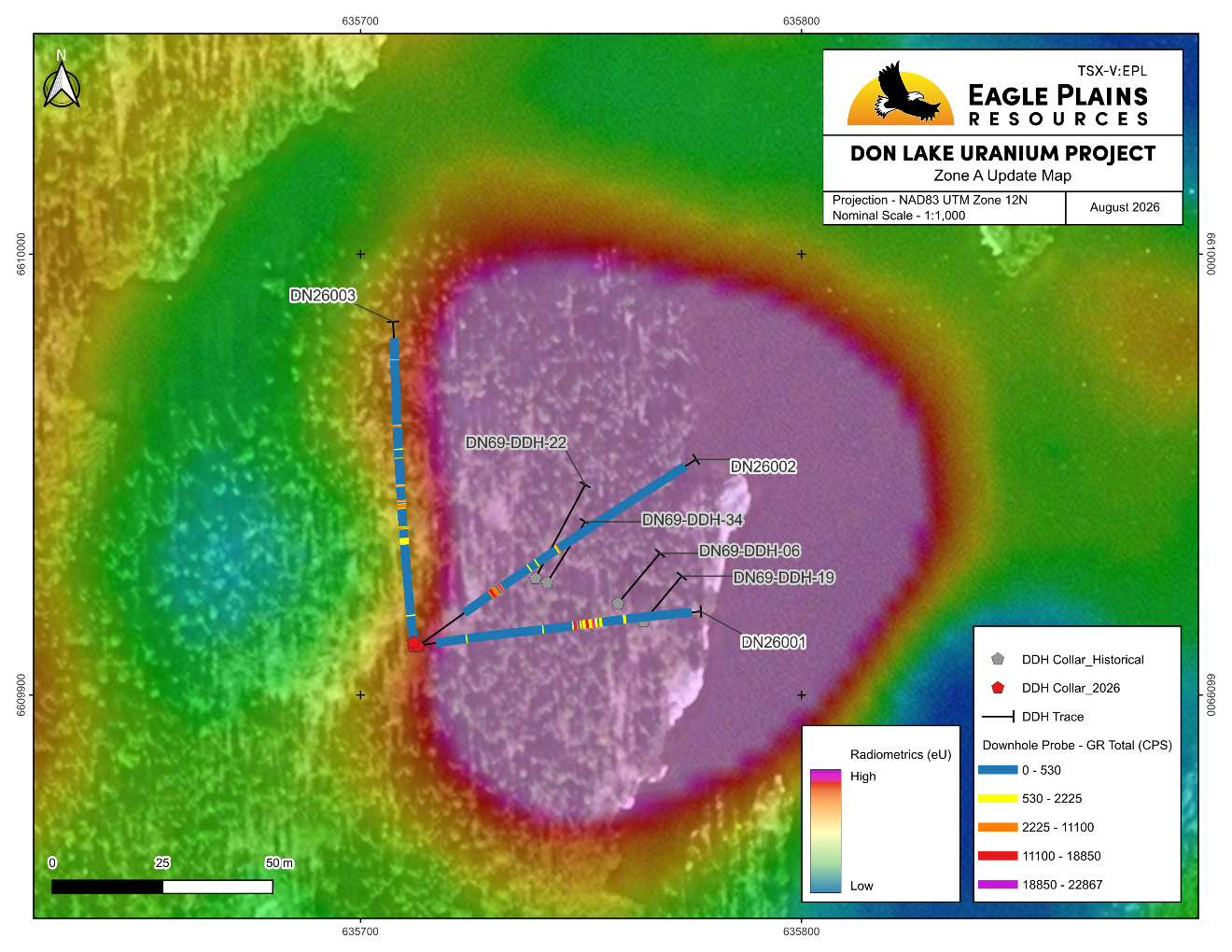
Figure 1 Zone A Update Map
Table 2 2026 Drill Results
Downhole Gamma Probe 1,2 | Hand Held Scintillometer 1,3 | |||||||
Hole Number | From | To | Width (m) | Max (CPS) | Average over width (CPS) | Depth (m) | (CPS) | |
DN26001 | 54.93 | 56.83 | 1.9 | 27474.2 | 11571 | 55 | 51978 | |
57.53 | 58.23 | 0.7 | 8844.09 | 3813 | ||||
58.93 | 62.83 | 3.9 | 34254 | 7649 | ||||
including | 59.33 | 60.43 | 1.1 | 21096.1 | 11151 | |||
including | 61.43 | 62.33 | 0.9 | 34254.3 | 13428 | |||
DN26002 | 31.13 | 33.83 | 2.7 | 33940.6 | 8186 | 32.5 | 18000 | |
34.83 | 35.93 | 1.1 | 23923 | 11753 | ||||
49.63 | 50.03 | 0.4 | 2320 | 1882 | ||||
57.93 | 58.53 | 0.6 | 3004 | 2058 | ||||
DN26003 | 10.03 | 10.63 | 0.6 | 2060 | 1000 | |||
33.53 | 35.73 | 2.2 | 3850 | 1450 | ||||
38.53 | 39.73 | 1.2 | 10320 | 2700 | ||||
45.33 | 48.43 | 3.1 | 7830 | 1920 | ||||
52.53 | 53.03 | 0.5 | 4000 | 2000 | ||||
72.13 | 72.63 | 0.5 | 6800 | 2900 | ||||
All depths and intervals are meters downhole, true thicknesses cannot yet be determined. Geochemical assays of drill core samples are pending.
1 Radioactive anomaly intervals are defined statistically at greater than 3 times average background counts: (i) at >800 counts per second (cps) measured with a Radiation Solutions BGO Super Spec ("RS-230") hand held Gamma Ray Spectrometer, or >900 cps measured with the Mount Sopris ("2SNA-1000") down hole spectral gamma probe, (ii) is accompanied by structure, hydrothermal alteration, or uranium mineralization typical of Beaverlodge type, or basement-hosted Athabasca unconformity type related uranium deposits, and (iii) spectrometric analyses by RS-230 or 2SNA-1000 probe indicates uranium to be the dominant source.
2 Radioactivity is total gamma in counts per second (cps) measured downhole via the Mount Sopris 2SNA-1000 spectral gamma probe with data collected at 10cm intervals
3 Peak radioactivity is total gamma in counts per second (cps) from surface drill core measured with a RS-230 hand-held spectrometer
All of the drillholes intersected mainly gabbroic gneiss with moderate to strongly developed quartz veining, silicification +/-potassic alteration, and hematization. Other rock types include semi-pelite gneiss, and rare mafic dykes. Anomalous radioactivity is generally associated with the gabbroic gneiss.
The 2026 drilling program is testing for shallow, structurally-controlled uranium mineralization west of the Black Bay Fault, and north of the Townsend Fault, within the Don and Midas Targets. The holes are aligned to target the intersection between NE-trending and NW-trending structures. In the Don Target area, the drilling will test for extensions of high-grade uranium mineralization beneath the A, B, C Zone trenches and the Hawker trenches. At the Midas zone, drilling will target the source of the coincident 2026 uranium geochemical anomalies, and the strong anomaly defined by the 2026 radiometric survey.
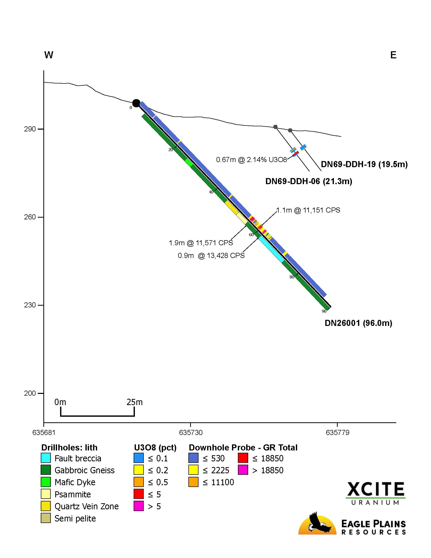
Figure 2 DN26001 Section
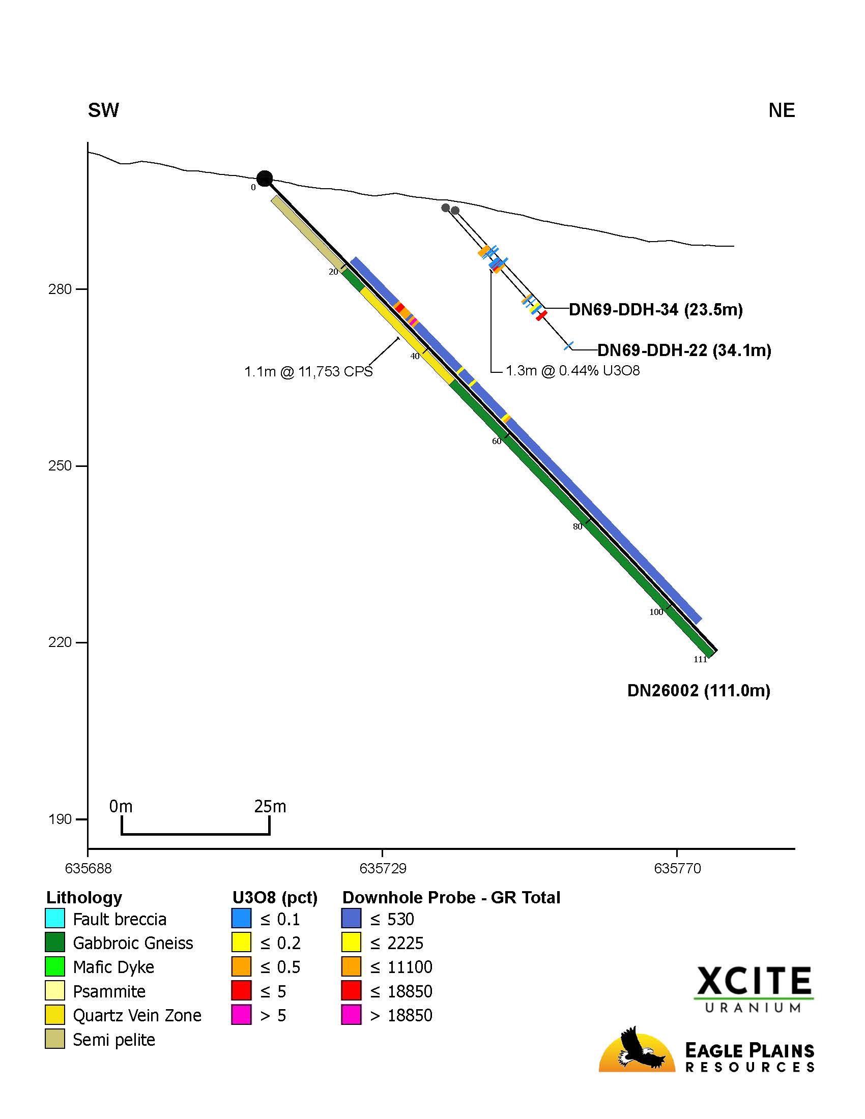
Figure 3 DN26002 Section
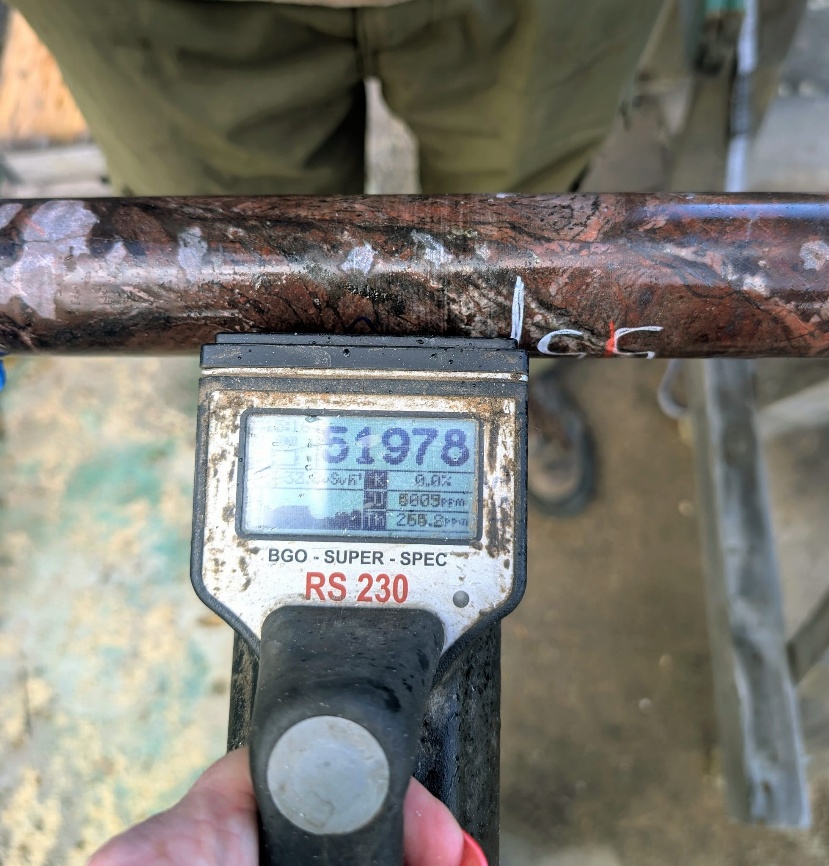
Figure 4 DDH DN26001 55.0m
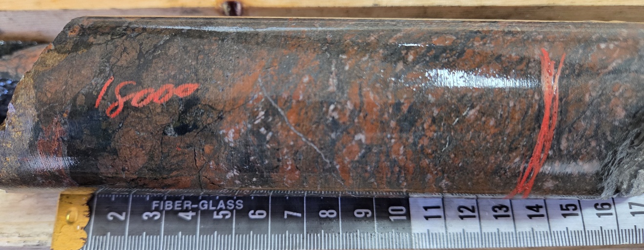
Figure 5 DDH DN26002 32.5m
See Don Lake Compilation Map
Don Lake Project Highlights
Twelve SMDI uranium occurrences
Tenures cover past producing Beta Gamma Mine (SMDI 1394) and the Don Lake Uranium Deposit (SMDI 1393)
Historical drilling at A Zone returned values of 10.7% U3O8 over 0.3m and 2.14% U3O8 over 0.67m (AF 74N10-0422).
Trench samples up to 1.17% U3O8 over 1.98m (AF 74N10-0422).
The approved 2026 budget for Don Lake is approximately $1.1 million, consisting of $200,000 in fieldwork (completed) and $900,000 allocated for drilling. All work is managed by TerraLogic Exploration Inc.
See Don Lake Project Information and Map here
About the Don Lake Project
The road accessible 1671ha project overlies 12 Saskatchewan Mineral Deposit Index ("SMDI") occurrences associated with Beaverlodge-type basement hosted uranium mineralization.
The property is transversed by the parallel, northeasterly-striking Boom Lake and Black Bay Fault, the latter of which is a regional structure that is inferred to control uranium mineralization in the Beaverlodge camp. In the southeast corner of the property Martin Group sediments form an unconformable contact with older Tazin Group gneisses, along the hanging wall of the Black Bay Fault.
Uranium mineralization at Don Lake is structurally controlled, occurring as pitchblende hosted in fractures and veins associated with faults and shear zones, and often associated with graphite and sulphides.
Three zones of radioactivity and U mineralization have been identified at the Don Lake A, B and C Zones (SMDI 1393), which has been traced by historical drilling and trenching over approximately 525m.
Zone A is a vein system with a length of 213.4 m, that crosses the trend of a northeast-striking lineament. Fourteen trenches and 20 shallow drill holes have been completed over the zone. Analytical results range from trace values up to 8.57% U3O8 over 0.91m and 2.86% U3O8 over 0.61m in trenching and 10.7% U3O8 over 0.3m and 2.14% U3O8 over 0.67m in drilling (AF74N10-0422).
Zone B, positioned to the northwest and interpreted to be a continuation of the mineralized trend observed at Zone A, has seen 12 shallow diamond drill holes and 20 trenches completed. Trench sampling reported grades as high as1.17% U3O8 over 1.98m, with drilling results including 0.71% U3O8 over 0.34m and 0.64% U3O8 over 0.3m. The uranium mineralization occurs in series of veins and fractures.
Zone C is positioned to the southeast of Zones A and B and further defines the NW-SE mineralized trend. 6 shallow drillholes and 9 trenches have been completed at Zone C, where trench samples returned from trace amounts up to 3.02% U3O8 over 0.61m and drilling intercepts included 0.80% U3O8 over 0.3m and 0.85% U3O8 over 0.52m.
At Radioactive Occurrence 50-CC3-10 and -44 (SMDI 1383), and the Midas Cu-U Showing (SMDI 1384) pitchblende occurs as in shears associated with the Crackingstone Fault. Showings associated with the Townsend Fault Uranium Showings (SMDI 1385) host pitchblende in fracture splays and breccia zones. A 10 ft (3.1 m) channel sample taken across a width of 1.0 ft (0.30 m) assayed 1.63% U3O8. (AF74N10-0056).
At the A.R. Hawker Trench ARH-2 (SMDI 2116) structurally controlled uranium and sulphide mineralization is associated with net textured quartz veins. Grab samples from trenches and surface showings returned from trace values up to 1.2% and 0.78% U3O8 (AF74N10-0453).
Don Lake History
Anomalous radioactivity at Don Lake was first noted by the Geological Survey of Canada in 1948, with the first claims recorded later that year by the Eldorado Mining and Refining Company. In 1950, Aurora Yellowknife Mines identified 28 radioactive occurrences on the property, including the 50-CC3-10 and 50-CC3-44 (SMDI 1383), Midas Cu-U Showing (1384) and Townsend Fault Uranium Showings (SMDI 1385). The same year Eldorado completed three short diamond drill holes at the Don Lake Zone A showing (SMDI 1393), with hole D-1 returning 2.0% U3O8 over 0.6m from 49.7-50.3m (AF 74N10-0345).
Between 1948-1968, various operators conducted work within the current Don Lake tenure, including prospecting, scintillometer surveying, trenching and limited diamond drilling. Most of this work is poorly documented. The next significant work was by Matrix Exploration in 1969, who carried out prospecting, scintillometer surveying, trenching and the 1200m of diamond drilling in 37 holes at the Don Lake A, B, and C Zones. Trenching in the A Zone returned from trace values up to 8.57% U3O8 over 0.91m and 2.86% U3O8 over 0.61m. The best drill intercept was from Zone A, where hole 23 returned 10.7% U3O8 over 0.3m (AF 74N10-0422).
Between 1971-78 August Hawker, Matrix Exploration and Kodiak Developments carried out prospecting, scintillometer surveys, trenching, and ground geophysics on various areas of the current Don Lake tenure.
Parts of the property were covered by airborne geophysics flown by Greater Lenora Resources Corp in 1997 (EM) and by the Geological Survey of Canada and Saskatchewan Energy and Mines who contracted Sander Geophysics to obtain gamma-ray spectrometric, aeromagnetic and VLF-EM data in 2000, the last significant work on the property.
See Uranium City Projects map here
The Uranium City projects are included in a formal Exploration Agreement between Eagle Plains and the Ya'thi Néné Lands and Resource Office ("YNLR"), representing the Athabasca Denesułiné First Nations of Hatchet Lake, Black Lake, and Fond du Lac, the Northern Hamlet of Stony Rapids, and the Northern Settlements of Uranium City, Wollaston Lake and Camsell Portage.
Rock grab samples are selective samples by nature and as such are not necessarily representative of the mineralization hosted across the property. Some of the above results were taken directly from the SMDI descriptions and assessment reports (AF) filed with the Saskatchewan government. Management cautions that historical results were collected and reported by past operators and have not been verified nor confirmed by a Qualified Person, but form a basis for ongoing work on the subject properties. Management cautions that past results or discoveries on proximate land are not necessarily indicative of the results that may be achieved on the subject properties.
Natural gamma radiation from rocks reported in this news release was measured in counts per second ("cps") using a handheld RS-230 spectrometer or 2SNA-1000 down hole spectral gamma probe. Readers are cautioned that measurements of total gamma on drill core are an indication of uranium content, but may not correlate with chemical assays.
About the Beaverlodge Uranium District
The Beaver River, Black Bay, Don Lake, Gulch, Lorado, and Smitty projects are located in the Beaverlodge District near Uranium City in the Lake Athabasca region of Saskatchewan. Occurrences of uranium mineralization are abundant in the Uranium City area and have been explored and documented since the 1940s. The Beaverlodge camp was the first uranium producer in Canada, with historic production of approximately 70.25 million pounds of U3O8 between 1950-1982, from ore grades averaging 0.23% U3O8. The two largest producers were the Eldorado Beaverlodge (Ace-Fay-Verna) mine and the Gunnar uranium mine. The Beaverlodge area has seen limited uranium focused exploration since the early 1990's.
The Uranium City area projects have potential for both Beaverlodge-style and basement-hosted uranium mineralization. Key features about the projects include:
Outcropping, largely northeast-southwest-trending tectonic fabric;
Electromagnetic conductors that have been confirmed as graphite-rich pelites within or near major faults;
Anomalous uranium geochemistry and radioactivity associated with graphitic faults;
Compelling property-wide evidence for hydrothermal alteration;
Uranium mineralization with corresponding elevations in pathfinder elements.
These factors, along with the presence of a substantial uranium endowment in both basement rocks and Athabasca basin cover rocks, indicate excellent potential for economic uranium mineralization within the project. The mineralization, structures and alteration identified on the claims to date are strong indicators of the possibility of a nearby source for the uranium mineralization.
Uranium City Option Agreement
Under the terms of the agreements, Xcite may earn an 80% interest in each of the Beaver River, Black Bay, Don Lake, Gulch, Lorado, and Smitty projects by completing CDN$3,200,000 in exploration expenditures, issuing 750,000 common shares of Xcite and making cash payments to Eagle Plains of CDN$55,000 over four years, for an aggregate of CDN$19,200,000 in exploration expenditures, 4,500,000 shares and $330,000 in cash to Eagle Plains. Upon Xcite fulfilling the terms of any or all of the earn-in agreements, an 80/20 joint venture will be formed, with Eagle Plains retaining a carried interest in all expenditures until delivery by Xcite or its assigns of a bankable feasibility study. During the option earn in period, XRI will be appointed as operator, and EPL will manage the exploration programs under the direction of a joint technical committee. The projects are owned 100% by EPL, who will retain an underlying 2% NSR royalty on the each of the properties.
Qualified Person
Technical information in this News Release has been reviewed and approved by C.C. Downie, P.Geo., a director and officer of Eagle Plains, hereby identified as the "Qualified Person" under N.I. 43-101.
About Eagle Plains Resources
Based in Cranbrook, B.C., Eagle Plains is a well-funded, prolific project generator that continues to conduct research, acquire and explore mineral projects throughout western Canada, with a focus on critical metals integral to an increasingly electrified, decarbonized economy.
The Company was formed in 1992 and is the fourth-oldest listed issuer on the TSX-V (and the only one of these four that has not seen a roll-back or restructuring of its shares). Eagle Plains has continued to deliver shareholder value over the years and through numerous spin outs has transferred over $115,000,000 in value directly to its shareholders, with Copper Canyon Resources and Taiga Gold Corp. being notable examples. Eagle Plains latest spinout, Eagle Royalties Ltd. (CSE:"ER") was listed on May 24, 2023, and on October 30, 2025, ER shareholders overwhelmingly approved a three-cornered amalgamation that resulted in a reverse takeover of Eagle Royalties by Summit Royalty Corp. The resulting issuer is named Summit Royalties Ltd. and trades under the symbol SUM on the TSX Venture Exchange with a market capitalization of over $100M.
On October 2, 2024, Eagle Plains announced the formation of a separate division within the Company that will give Eagle Plains' shareholders direct exposure to strategic opportunities in Canadian green energy transition. As a wholly owned subsidiary of Eagle Plains, Osprey Power Inc. ("OP") will focus on identifying and advancing innovative and diverse clean energy project portfolios in target markets throughout Canada, with an initial focus on Western Canada.
Eagle Plains' core business is acquiring grassroots critical- and precious-metal exploration properties. The Company is committed to steadily enhancing shareholder value by advancing our diverse portfolio of projects toward discovery through collaborative partnerships and development of a highly experienced technical team.
Expenditures from 2010-2025 on Eagle Plains-related projects exceed $41M, the majority of which was funded by third-party partners. This exploration work resulted in approximately 50,000m of diamond-drilling and extensive ground-based exploration work facilitating the advancement of numerous projects at various stages of development.
Throughout the exploration process, our mission is to help maintain prosperous communities by exploring for and discovering resource opportunities while building lasting relationships through honest and respectful business practices.
On behalf of the Board of Directors of Eagle Plains
"C.C. (Chuck) Downie, P.Geo"
President and CEO
For further information on EPL, please contact Andrew Wilson at 1 866 HUNT ORE (486 8673)
Email: [email protected] or visit our website at https://www.eagleplains.com
Cautionary Note Regarding Forward-Looking Statements
Neither the TSX Venture Exchange nor its Regulation Services Provider (as that term is defined in the policies of the TSX Venture Exchange) accepts responsibility for the adequacy or accuracy of this release. This news release may contain forward-looking statements including but not limited to comments regarding the timing and content of upcoming work programs, geological interpretations, receipt of property titles, potential mineral recovery processes, etc. Forward-looking statements address future events and conditions and therefore, involve inherent risks and uncertainties. Actual results may differ materially from those currently anticipated in such statements.
SOURCE: Eagle Plains Resources Ltd.
View the original press release on ACCESS Newswire
L.Coleman--TFWP