
Rocky Shore Gold Discovers Bulk-Style Gold Zone at the Gold Anchor Project, Drill Program Expands From 3,500 Metres to 12,500 Metres

TORONTO, ON / ACCESS Newswire / June 10, 2026 / Rocky Shore Gold Ltd. ("Rocky Shore" or the "Company") (CSE:RSG)(OTCQB:RSGLF) is pleased to report that its initial reconnaissance drill program at the Lane Pond Gold Target has identified an near-surface bulk-style gold zone, interpreted to be associated with the prolific Appleton Fault. The Appleton Fault and its subsidiary splays are among the region's priority gold-bearing structural corridors and host several gold deposits and recent discoveries northeast of the Company's Gold Anchor Project.
To date, 13 holes have been completed, with samples from three holes assayed and reported. Results from the remaining holes will be released once received. Bulk-style gold intervals from the three reported holes, interpreted as approximate true thicknesses, are highlighted below.
13.26 metres grading 0.41 g/t Au, including 2.70 metres grading 1.00 g/t Au (LP-26-01)
14.91 metres grading 0.44 g/t Au, including 3.99 metres grading 1.10 g/t Au (LP-26-01)
8.11 metres grading 0.84 g/t Au, including 5.03 metres grading 1.10 g/t Au (LP-26-02)
17.02 metres grading 0.65 g/t Au, including 8.7 metres grading 1.02 g/t Au and 4.35 metres grading 1.41 g/t Au (LP-26-07)
The gold zone has been intersected in eight widely spaced drill holes over 400 metres of strike, 600 metres down-dip, and from 50 to 240 metres vertically, and remains open in all directions. The discovery lies within the 11.0-kilometre Lane Pond Gold Target, a largely untested north-trending VTEM geophysical anomaly east of the Company's Mosquito Hill and Reid open-pit gold deposits (see Map 1 below). The Gold Anchor Project forms part of an emerging gold district in central Newfoundland (see Map 2 below).
Ken Lapierre, President and CEO of Rocky Shore, commented: "The first phase of drilling at Lane Pond has delivered exactly what an early reconnaissance program is meant to achieve: confirmation of a large, gold-bearing, sulphide-rich alteration zone in a highly prospective structural setting. These initial assays show that the system contains gold and, just as importantly, that drilling has defined scale, continuity, and clear targets for follow-up work.
Lane Pond is not a small, isolated target. It lies within an 11.0-kilometre geophysical, geological, and structural trend linked to the Appleton Fault Corridor, one of central Newfoundland's key gold-bearing fault systems. Importantly, drilling to date has tested only a small part of this broader corridor. The combination of Induced Polarization signatures, the VTEM response, and current drill results indicates that the sulphide-bearing, quartz-carbonate stockwork bulk-style gold zone could extend beyond the area drilled so far, and that we are still in the early stages of assessing a potentially larger system.
The additional 9,000 metres of drilling reflects our view that Gold Anchor could host multiple gold systems, including broad bulk-style mineralization and higher-grade, structurally controlled zones. The next phase of drilling will further define the scale of the bulk-style gold zone while targeting the most prospective structural and geophysical areas for stronger gold mineralization.
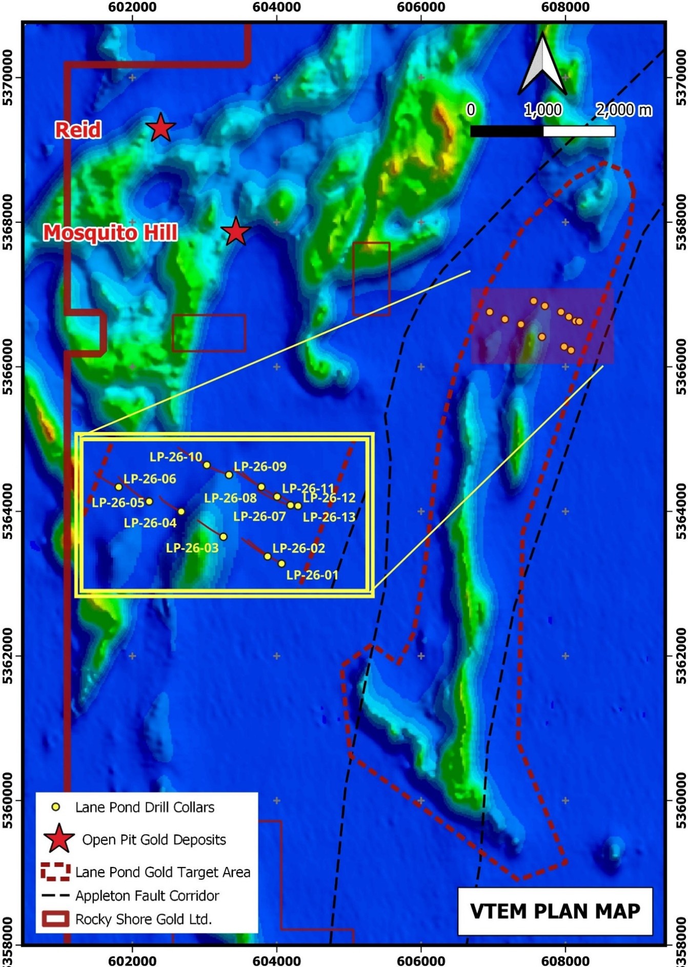
Map 1: VTEM geophysical map showing the Phase One drill-hole locations. The bulk-style gold zone intersected by drilling is associated with the 11.0-kilometre VTEM anomaly, interpreted as part of the Appleton Fault Corridor and the Lane Pond Gold Target. The Mosquito Hill and Reid gold deposits (bulk-tonnage open pits), shown as red stars, lie west of the Lane Pond Gold Target.
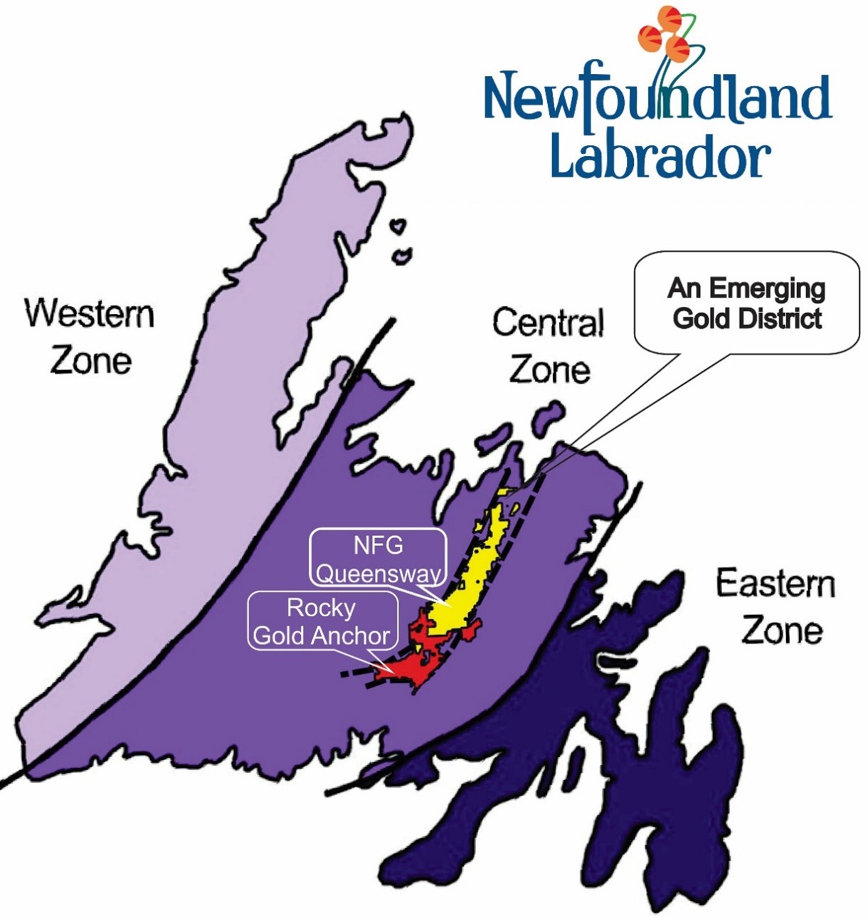
Map 2: Emerging Gold District in Central Newfoundland. Rocky Shore (red). NFG (yellow).
Phase One Drilling at the Lane Pond Gold Target
A total of 13 drill holes, comprising 4,390 metres, have been completed in the central part of the Lane Pond Gold Target (see Map 1 above). Assay results have been received for three holes (LP-26-01, LP-26-02, and LP-26-07). The bulk-style gold zone discovery is associated with the Appleton Fault, a major gold-bearing structure that hosts significant remobilized and enriched gold mineralization along second and third-order fault splays northeast of the project. The zone has been intersected over 400 metres of strike, more than 600 metres down dip, and from 50 metres to more than 240 metres vertically. It remains open in all directions and is linked to an extensive, largely untested, north-trending VTEM geophysical anomaly that defines the 11.0-kilometre Lane Pond Gold Target. The bulk-style gold zone occurs within a weakly to strongly altered, foliated, graphitic, sheared, mineralized quartz-carbonate stockwork. Mineralization, reaching up to 20% by volume, includes pyrite and arsenopyrite, with lesser chalcopyrite, sphalerite, galena, stibnite, and pyrrhotite. Associated lithologies include conglomerate, graphitic shale, graphitic fault zones, and siltstone.
Drill Assay Summary (holes LP-26-01, 02, 07).
Drill Hole | From (m) | To (m) | Length (m)* | Au g/t |
LP-26-01 | 284.24 | 297.50 | 13.26 | 0.41 |
including | 284.24 | 286.94 | 2.70 | 1.00 |
and | 324.25 | 339.16 | 14.91 | 0.44 |
including | 335.17 | 339.16 | 3.99 | 1.10 |
including | 336.19 | 339.16 | 2.97 | 1.30 |
LP-26-02 | 270.37 | 278.48 | 8.11 | 0.84 |
including | 271.37 | 276.40 | 5.03 | 1.10 |
LP-26-07 | 280.60 | 297.62 | 17.02 | 0.65 |
including | 288.92 | 297.62 | 8.70 | 1.02 |
including | 292.00 | 296.35 | 4.35 | 1.41 |
*Note: Lengths reported are drill lengths, which are estimated to represent approximately true thickness.
Drill Plan Summary
Drill Hole | Easting | Northing | Dip | Azimuth | Length (m) |
LP-26-01 | 608077 | 5366228 | -45 | 295 | 439 |
LP-26-02 | 607980 | 5366278 | -45 | 295 | 319 |
LP-26-03 | 607674 | 5366414 | -45 | 295 | 307 |
LP-26-04 | 607382 | 5366588 | -45 | 295 | 271 |
LP-26-05 | 607160 | 5366658 | -45 | 295 | 379 |
LP-26-06 | 606949 | 5366758 | -45 | 295 | 271 |
LP-26-07 | 608139 | 5366632 | -45 | 295 | 340 |
LP-26-08 | 607937 | 5366759 | -45 | 295 | 331 |
LP-26-09 | 607713 | 5366842 | -45 | 295 | 262 |
LP-26-10 | 607559 | 5366910 | -45 | 295 | 334 |
LP-26-11 | 608044 | 5366700 | -45 | 295 | 409 |
LP-26-12 | 608191 | 5366627 | -60 | 295 | 349 |
LP-26-13 | 608191 | 5366627 | -82 | 295 | 379 |
Quality Control and Reporting Protocols
All samples are collected and prepared for shipment in the field for submission to Eastern Analytical Ltd. in Springdale, Newfoundland, an ISO 17025 Certified Analytical Testing Facility, for 34 Element ICP Analysis. Eastern Analytical is independent of Rocky Shore. Blank and Certified Reference Material (CRM) are included, such that for every 18 samples, 1 blank and 1 CRM are included. Samples are shipped directly by in-field personnel, who maintain the chain of custody until samples are delivered to the laboratory. Rock preparation at the lab involves crushing up to 3kg to 80% passing 10 mesh, 250 grams split, and pulverizing to 95% passing 150 mesh. For gold analysis, a 30g sample is subjected to a fire assay, digested in aqua regia, and analyzed by atomic absorption (AA).
Qualified Person
The scientific and technical information in this press release has been prepared and approved by Ken Lapierre, P. Geo., President and CEO of the Company, and a Qualified Person in accordance with the Canadian regulatory requirements as set out in National Instrument 43-101. Mr. Lapierre consents to the publication of this press release dated June 10, 2026, by Rocky Shore Gold Ltd.
About Rocky Shore Gold Ltd.
Rocky Shore Gold is a Canadian junior exploration company focused on its 100%-owned Gold Anchor Project in central Newfoundland. It is strategically located within one of Canada's most promising and underexplored gold belts. The Project is the second-largest property (greater than 1,200 square kilometres) in the emerging gold district. Rocky Shore is targeting the expansion of its structurally controlled, orogenic-hosted, surface bulk-tonnage Mosquito Hill and Reid Gold Deposits, associated with the Dog Bay Line Fault. It also hosts orogenic, structurally controlled gold targets along the highly prospective Appleton and JBP Faults, as well as numerous additional faults located southwest of major gold discoveries and deposits.
Please visit our website at www.rockyshoregold.com.
Rocky Shore Gold would like to acknowledge the $150,000 in financial support received for 2025, and the approval of the 2026 Junior Exploration Assistance (JEA) administered by the Mineral Incentive Program from the Mineral Development Division, Department of Energy and Mines, Government of Newfoundland and Labrador.
For more information, please contact:
Ken Lapierre, President & CEO
Rocky Shore Gold Ltd.
T: +1 (647) 678-3879
E: [email protected]
Cathy Hume, CEO
CHF Capital Markets
T: +1 (416) 868-1079 x 251
E: [email protected]
Twitter: @RockyShoreGold
LinkedIn: @RockyShoreGold
Forward-Looking Information
This news release contains "forward-looking information" and "forward-looking statements" (collectively, "forward-looking information") within the meaning of applicable Canadian and United States securities laws. Generally, forward-looking information can be identified by the use of forward-looking terminology such as "plans", "expects", or "does not expect", "is expected", "budget", "scheduled", "estimates", "forecasts", "intends", "anticipates", or "does not anticipate", or "believes" or variations of such words and phrases or state that certain actions, events or results "may", "could", "would", "might", or "will be taken", "occur", or "be achieved". Certain information set forth in this news release may contain forward-looking information that involves substantial known and unknown risks and uncertainties, including, but not limited to the results of exploration and the advancement of the Company's properties, the exploration potential, the price of gold, the geology and potential mineralization of the Gold Anchor project and the advancement of the Company's mineral properties. The forward-looking information is based on reasonable assumptions and estimates of the management of the Company at the time such statements were made and is subject to known and unknown risks, uncertainties and other factors that may cause the actual results, level of activity, performance or achievements of the Company to be materially different from those expressed or implied by such forward-looking information, including risks associated with the exploration; future commodity prices; changes in regulations; political or economic developments; environmental risks; permitting timelines; capital expenditures; technical difficulties in connection with exploration activities; employee relations; the speculative nature of mineral resource exploration including the risks of diminishing quantities of grades of mineral resources, contests over title to properties, the Company's limited operating history, future capital needs and uncertainty of additional financing, and the competitive nature of the mining industry; the need for the Company to manage its future strategic plans; global economic and financial market conditions; uninsurable risks; and changes in project parameters as plans continue to be evaluated. Although the Company has attempted to identify important factors that could cause actual results to differ materially from those contained in the forward-looking information, there may be other factors that cause results not to be as anticipated, estimated or intended. Although the forward-looking information contained in this news release is based upon what management of the Company believes, or believed at the time, to be reasonable assumptions, the Company cannot assure shareholders that actual results will be consistent with such forward-looking information, as there may be other factors that cause results not to be as anticipated, estimated or intended. Accordingly, readers should not place undue reliance on forward-looking information. There can be no assurance that forward-looking information, or the material factors or assumptions used to develop such forward-looking information, will prove to be accurate. The Company does not undertake any obligations to release publicly any revisions for updating any voluntary forward-looking information, except as required by applicable securities law.
Neither the Canadian Securities Exchange nor its Market Regulator (as that term is defined in the policies of the Canadian Securities Exchange) accepts responsibility for the adequacy or accuracy of this release.
SOURCE: Rocky Shore Gold Ltd.
View the original press release on ACCESS Newswire
S.Weaver--TFWP