The Fort Worth Press - Hurricane Erin drenches Caribbean islands, threatens US coast

USD -
AED 3.672495
AFN 62.999984
ALL 80.627789
AMD 363.380057
ANG 1.790365
AOA 918.000055
ARS 1517.972499
AUD 1.425903
AWG 1.8
AZN 1.69841
BAM 1.71977
BBD 2.014306
BDT 123.289177
BGN 1.683441
BHD 0.377028
BIF 3012.807267
BMD 1
BND 1.279847
BOB 12.085376
BRL 5.192397
BSD 1.000119
BTN 95.910598
BWP 13.673072
BYN 3.044111
BYR 19600
BZD 2.011325
CAD 1.414299
CDF 2310.000241
CHF 0.829375
CLF 0.024466
CLP 966.07002
CNY 6.71135
CNH 6.716645
COP 3327.29
CRC 454.67135
CUC 1
CUP 24.002321
CVE 96.957999
CZK 21.476201
DJF 178.083758
DKK 6.575975
DOP 59.432581
DZD 133.865841
EGP 51.777898
ERN 15
ETB 163.34979
EUR 0.87968
FJD 2.24975
FKP 0.754629
GBP 0.756825
GEL 2.615037
GGP 0.754629
GHS 11.590355
GIP 0.754629
GMD 74.000457
GNF 8795.817964
GTQ 7.637756
GYD 209.235666
HKD 7.84281
HNL 26.840946
HRK 6.625197
HTG 130.885334
HUF 322.220499
IDR 17993
ILS 3.04725
IMP 0.754629
INR 95.98845
IQD 1310.172301
IRR 1374575.000394
ISK 121.219779
JEP 0.754629
JMD 157.732063
JOD 0.709017
JPY 158.955005
KES 129.449631
KGS 87.449698
KHR 4068.37186
KMF 432.999863
KPW 900.000318
KRW 1370.284991
KWD 0.30891
KYD 0.833348
KZT 441.759759
LAK 22415.75627
LBP 89553.909393
LKR 330.087184
LRD 172.006612
LSL 16.429705
LTL 2.95274
LVL 0.60489
LYD 6.396131
MAD 9.575819
MDL 17.795832
MGA 4384.028981
MKD 54.094692
MMK 2099.566963
MNT 3597.939506
MOP 8.078394
MRU 40.034469
MUR 47.780056
MVR 15.449702
MWK 1734.061354
MXN 17.661465
MYR 4.085395
MZN 63.909902
NAD 16.429561
NGN 1326.199692
NIO 36.808252
NOK 9.521905
NPR 153.46825
NZD 1.768895
OMR 0.384505
PAB 1.000066
PEN 3.388188
PGK 4.455485
PHP 62.793008
PKR 277.092073
PLN 3.85592
PYG 5926.499101
QAR 3.6455
RON 4.6417
RSD 103.364968
RUB 85.004112
RWF 1479.504809
SAR 3.756357
SBD 8.000512
SCR 13.765011
SDG 601.509279
SEK 9.94637
SGD 1.280959
SHP 0.755002
SLE 24.650187
SLL 20969.491881
SOS 571.546649
SRD 37.694988
STD 20697.981008
STN 21.542912
SVC 8.750973
SYP 13002.000254
SZL 16.42566
THB 33.503007
TJS 9.215477
TMT 3.51
TND 2.958465
TOP 2.40776
TRY 48.854898
TTD 6.801985
TWD 31.828504
TZS 2644.998032
UAH 45.026248
UGX 3925.206526
UYU 40.068936
UZS 11810.999389
VES 852.43145
VND 25992
VUV 118.51472
WST 2.751818
XAF 577.032019
XAG 0.015834
XAU 0.000235292457
XCD 2.70255
XCG 1.802315
XDR 0.707052
XOF 577.032019
XPF 104.867465
YER 236.649703
ZAR 16.45715
ZMK 9001.204613
ZMW 19.450905
ZWL 321.999592
SSP 5712.591861
MXV 2.001557
  • RIO

    -0.3300

    97.04

    -0.34%

  • CMSC

    -0.0400

    20.67

    -0.19%

  • RELX

    0.0000

    33.41

    0%

  • RBGPF

    0.0000

    67.95

    0%

  • BCE

    -0.0700

    21.99

    -0.32%

  • BCC

    -0.0300

    75.66

    -0.04%

  • GSK

    0.8600

    51.08

    +1.68%

  • JRI

    -0.0300

    11.52

    -0.26%

  • NGG

    -0.1200

    76.68

    -0.16%

  • CMSD

    0.0900

    20.54

    +0.44%

  • BTI

    -0.0800

    55.75

    -0.14%

  • AZN

    2.0200

    168.1

    +1.2%

  • BP

    -1.4200

    43.16

    -3.29%

  • RYCEF

    0.4600

    19.7

    +2.34%

  • VOD

    0.0700

    17.02

    +0.41%

Hurricane Erin drenches Caribbean islands, threatens US coast
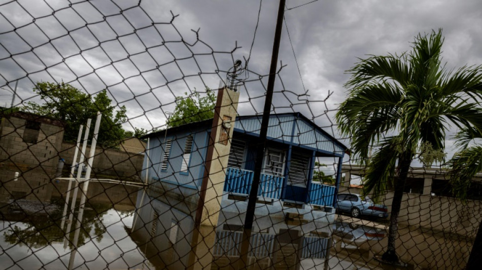
Hurricane Erin drenches Caribbean islands, threatens US coast / Photo: © AFP

Hurricane Erin drenches Caribbean islands, threatens US coast

Hurricane Erin strengthened Monday and was forecast to expand as the powerful Category 4 storm drenched Caribbean islands and threatened dangerous rip currents along the US East Coast.

Text size:

In its latest advisory the US National Hurricane Center (NHC) said Erin was packing maximum sustained winds of 140 miles (220 kilometers) per hour while moving west-northwest at 10 mph.

Its outer bands were forecast to bring localized downpours across Cuba and the Dominican Republic through Monday as well as the Turks and Caicos and the Bahamas -- where a tropical storm warning is in place -- through Tuesday.

These areas could receive localized totals of up to six inches (15 centimeters) of rain, according to the NHC.

In Puerto Rico, a US territory of more than three million people, weekend flooding swamped homes and roads in the island's east, and widespread power outages left residents in the dark, though service has since been restored to more than 96 percent of customers.

Although Erin's core will remain over the Atlantic as it begins curving northeast this week, "Erin is expected to grow rather dramatically in size," warned NHC director Michael Brennan, stressing that peripheral impacts will be significant.

By Tuesday, the entire US East Coast will face a high risk of life-threatening surf and rip currents, which occur when channels of water surge away from the shore.

Coastal flooding, particularly along North Carolina's Outer Banks, is expected to begin Tuesday and peak Wednesday into Thursday, with portions of highway at risk of ocean overwash. Evacuations have been ordered off two islands, Ocracoke and Hatteras.

Wave heights of 20–30 feet (6-9 meters) -- at times exceeding 50 feet -- will create treacherous marine conditions across the western Atlantic.

The Atlantic hurricane season, which runs from June 1 to November 30, has now entered its historical peak.

Despite a relatively quiet start with just four named storms so far, the National Oceanic and Atmospheric Administration (NOAA) continues to forecast an "above-normal" season.

A typical season produces 14 named storms, of which seven become hurricanes and three strengthen into major hurricanes.

This year, tropical activity is expected to be elevated by a combination of warmer-than-average sea-surface temperatures in the tropical Atlantic and Caribbean, along with an active West African monsoon, NOAA said.

Scientists broadly agree that human-driven climate change is amplifying tropical cyclones.

Warmer oceans release more water vapor, fueling stronger winds, while a warmer atmosphere holds more moisture, intensifying rainfall.

Meanwhile, rising seas -- already about a foot higher than a century ago -- mean cyclones are starting from a higher baseline, magnifying storm surges and coastal flooding.

L.Coleman--TFWP